The Federal Emergency Management Agency (FEMA) is changing how flood insurance rates are calculated for your home and property. The National Flood Insurance Program (NFIP) is attempting to make flood insurance rates more equitable through an initiative called Risk Rating 2.0. FBCLID 2 is a FEMA-accredited levee system, so residents currently receive a “Preferred Rate” for flood insurance which typically costs less than $600 per year. The existing “Preferred Rate” will remain available through September, but on October 1, 2021 all new NFIP flood policies will be issued under the new pricing structure. Information provided by FEMA states that 23% of all policies will see an immediate decrease and 66% of policies will see a cost increase of less than $120 per year. As existing “Preferred Rate” policies expire, the cost will escalate up to 18% each year until the premium reaches the new Risk Rating 2.0 rate.
FEMA has not finalized how Risk Rating 2.0 will calculate new flood insurance rates for homes inside a levee like FBCLID 2. The District will continue to closely monitor all information released by FEMA and provide updates to the residents. FBCLID 2 is also working with Fort Bend County and the City of Sugar Land to monitor these upcoming flood insurance changes and how they will impact the community. FBCLID 2 encourages residents to check with your insurance carrier and discuss policy options for your property. For additional information check out www.FloodSmart.gov, the official website of the NFIP.

I live inside the FBCLID 2 levee. Should I buy flood insurance?
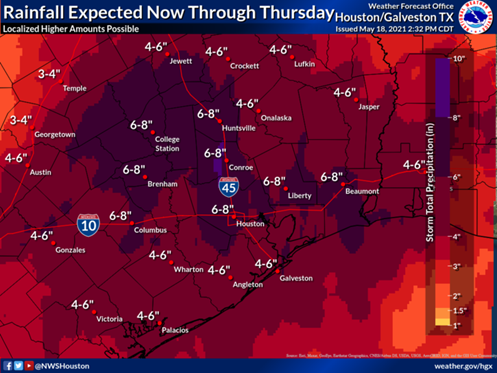
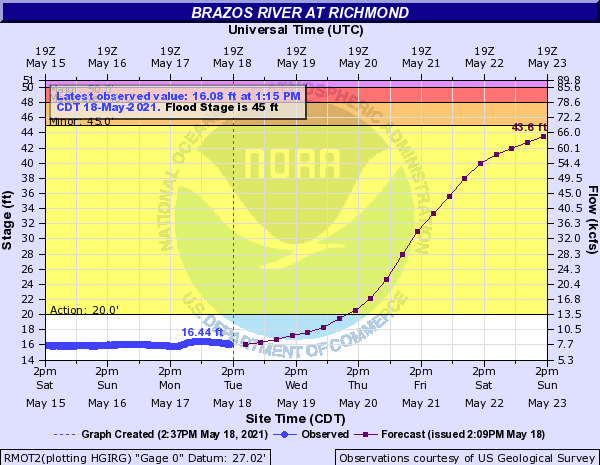
The answer is, Yes! Many property owners may be unaware that private home insurance policies do no cover losses caused by rising flood waters. The common example of rising flood waters in Fort Bend County is created by the Brazos River, but FBCLID 2 was created specially to mitigate that threat. However, very strong, localized rainfall in any part of FBCLID 2 can potentially overwhelm the design standards of the drainage system and trap water in streets and yards, eventually reaching into homes. The damaged caused by this type of loss is not included in a standard home insurance policy and would only be covered by purchasing a flood insurance policy that is supported by the NFIP.
While not a common occurrence, localized rainfall of 12+ inches in a day has occurred and will continue to occur across Southeast Texas. In recent memory, Hurricane Harvey dropped more than 30 inches of rain in Sugar Land and more than 50 inches in parts of Harris County. Looking further back, the 2016 Tax Day flood dropped more than a foot of rainfall in portions of Harris County, and in 2001 Tropical Storm Allison dropped 40 inches of precipitation on parts of Southeast Texas.