Rainfall and Brazos River Forecast: June 15, 2026

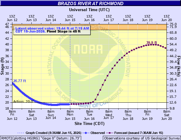
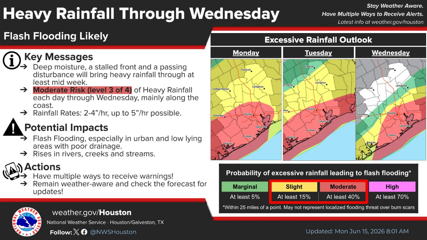
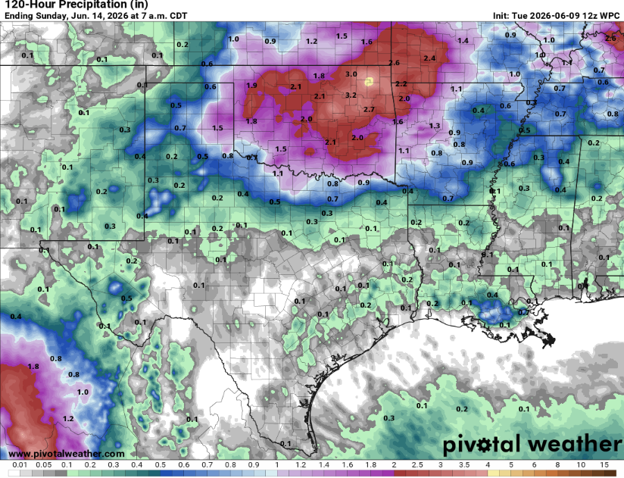
The Brazos River is forecasted to crest at 39.9 feet at the Richmond Gage on Friday, June 19. At this elevation, the Fort Bend County Levee Improvement District No. 2 (LID 2) flood gates can close and impact gravity drainage inside the levee. LID 2 is also forecasted to receive 4-7 inches of rainfall through Wednesday, and isolated totals over 10 inches are possible. Fortunately, the risk of heavy rainfall decreases later this week when the Brazos River elevation is high enough to close the flood gates. The LID 2 pump stations have been tested and operators are on stand-by, if needed. LID 2 residents are encouraged to bookmark the Emergency Operations website to receive the latest information: FBCLID2.com/EMERGENCY.

The latest forecast information from the National Weather Service is linked below. During any heavy rain event there may be street ponding or flooding if the storm drains are overwhelmed and back up. As rainfall decreases, the storm sewers will catch up, and any water in the streets will recede. Never drive into high water.

Brazos River at Richmond, TX

National Weather Service

Emergency Operations Update: Brazos River Forecast – June 9, 2026

The Brazos River is forecasted to crest at 32.3 feet at the Richmond Gage on Thursday, June 11.  At this elevation the Fort Bend County Levee Improvement District No. 2 (LID 2) drainage system continues to operate normally with gravity flow. Fortunately, LID 2 is forecasted to receive less than ¼” of rain over the next 5 days while the Brazos River is elevated. However, LID 2 is prepared if the situation changes. The pump stations have been tested and operators are on stand-by, if needed. LID 2 residents are encouraged to bookmark the Emergency Operations website to receive the latest information: FBCLID2.com/EMERGENCY. The latest forecast information from the National Weather Service is linked below.

Brazos River at Richmond, TX

National Weather Service

Rainfall Forecast

FBCLID 2 models award-winning improvements

FBCLID 2 recently updated the computer models that analyze the impact of rainfall on the drainage system inside the levee.  The models were updated to incorporate the $85 million capital improvement program that received the 2024 John Ivey Higher Standards Award from the Texas Floodplain Management Association (TFMA).

Immediately following Hurricane Harvey, FBCLID 2 used computer modeling to analyze the sources of flooding inside the levee and to design improvements to prevent them from reoccurring. For instance, the information gained from modeling helped determine the size of the new pump stations and estimated the benefits of drainage channel improvements.  Now that all Hurricane Harvey improvement projects are complete, the model was updated to reflect actual conditions instead of proposed improvements. The end result is confirmation that the $85 million investment in drainage improvements provided the expected results for FBCLID 2 and its residents.  The red-shaded areas on the map indicate the maximum extent of flooding during Hurricane Harvey.  The blue-shaded areas estimate the extent of flooding if all FBCLID 2 capital improvements were in place during Hurricane Harvey.  The only flood prone areas indicated in blue lie within existing drainage channels or golf course drainage easements.

FBCLID2 residents should note that street flooding is still possible and very likely during periods of intense, heavy rainfall. The streets in FBCLID 2 are designed to hold water when storm sewer inlets in the street are overwhelmed by heavy downpours. However, with additional pump and flood storage capacity, the FBCLID 2 drainage channels will stay at lower levels during heavy rains.  City street drains and storm sewers may still back up during heavy rain, but overall will perform better as a result of the FBCLID 2 improvements.

Hurricane Harvey Pre- and Post-Project Floodplain Map